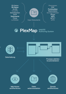
Basic workflow
Using Switchboard, Magazine and the PlexMap apps, you can build workflows to map in-house processes.
The first step is to import your geospatial data, services, and documents into Magazine as PlexMap's central data store. Each import process can be defined and automated. When updates are made, Magazine automatically creates a new time or edit stamp (moment). You have access to every moment and can thus, for example, also restore earlier versions of your data without loss.
The switchboard is then used to process geodata. More than 500 functions are available for this purpose - for example, spatial and attribute-based filter operations and geo functions. In addition, exports can be triggered here. Examples include creating a layer for a PlexMap app, providing a geoservice (WMS/WFS) or creating a data export for external software (e.g. ArcGIS, QGIS, MS Office, SketchUp, AutoCAD).
Finally, using the PlexMap Apps, the processed data is visualized via web maps. For each map, the layers used, the design, the tools available and the access rights are freely configurable. A comprehensive view editor is available for this individual configuration.
