Introduction
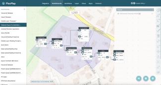
The Switchboard is a software for processing geodata via automatable workflows.
In the Switchboard, geodata and geofunctions are freely combined in the form of modules. In total, more than 500 functions are available with which you can build and execute workflows. A live preview shows the effects of all intermediate steps directly.
Results generated in the Switchboard can be exported as a file, published as a service (WMS/WFS) or used in the PlexMap apps.
The PlexMap Switchboard provides the following functions, among others:
- Perform geospatial functions (GDAL, OSGeo): buffer, blend, split or merge geometries, join information, and more
- Filtering: spatial and/or attribute-based selection of geodata
- Automation: switchboards can be executed automatically on demand (time- or event-driven)
- Data provision for external parties: ZIP, CSV, PDF, e-mail
- Provision of data for third-party software: interfaces to ArcGIS, QGIS, SketchUp, VIS-ALL, AutoCAD, Mapinfo and other systems
- Provision of services: publish WMS and WFS
- Speed: extremely fast computation times even with large amounts of data
- Collaboration: Switchboards can be shared with colleagues and edited together
- Users and user groups: the rights to edit geodata are freely configurable
- Create templates: You can save switchboards and reuse them as templates
