Panorama-Sphere
The type Panorama-Sphere describes a street panorama for PlexMap Street360°. It stores all relevant information such as camera position and camera The type Panorama-Sphere describes the shooting center of a spherical panorama for PlexMap Street360°. It stores all relevant information like camera position and camera orientation.
An object of type Panorama-Sphere must contain the name of the image capture ImageId as an attribute as well as the attributes Rotation, Heading, Roll, Pitch and HeightOffset. The panoramic images associated with each image capture center can be imported using the File type and stored in a layer together with the panoramic spheres for processing. An equirectangular 360° panoramic image is assumed.
ImageId Anchor
| Attribut | Funktion |
ImageId (string) | Image Name of the panorama |
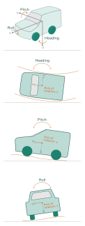
Heading(float) | Rotation around the negative z-axis |
Pitch(float) | Rotation around the negative y-axis |
Roll(float) | Rotation around the x-axis |
HeightOffset(float) | Shift of the hight of the panorama center point in the panorama |
CreationTime(string) | The time of image capture is displayed in the "Attribution" if set. |
ImageId Anchor
Heading Anchor
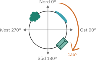
This attribute contains the angle in degrees that indicates the rotation around the negative z-axis in the ENU system (EastNorthUp). Heading (float) is also referred to as yaw or roll in the body-fixed coordinate system.
The angle indicates the deviation of the panoramic image center from the north direction.
For example, if the center of a panorama were exactly to the east, Heading would be exactly at 90°.
Pitch Anchor
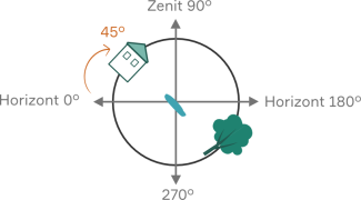
This attribute contains the angle in degrees that specifies the rotation around the negative y-axis in the ENU system (EastNorthUp). Pitch (float) is also referred to as pitch about the transverse axis in the body-fixed coordinate system.
Angle indicates the deviation of the panoramic image center from the horizon.
For example, if the center of a panorama were exactly at the zenith, Pitch would be exactly at 90°.
Roll Anchor
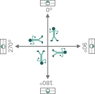
This attribute contains the angle in degrees that indicates the rotation around the x-axis in the ENU system (EastNorthUp). Roll (float) is also referred to as rolling and wobbling around the longitudinal axis in the body-fixed coordinate system.
The angle indicates the deviation of the horizon in the panorama from the actual horizon in PlexMap 3D.
For example, if Roll were 90°, viewers would have to look at the spherical panorama lying on their right ear to see the image correctly aligned.
HeightOffset Anchor
In this (optional) attribute the height difference between the height value from the point geometry and the actual panorama center point can be set. For example, if HeightOffset (float) is set to "2", the panoramic center point is 2 meters above the geometry point (in PlexMap 3D, the geometry point is used as the activation point).


