MapProxy (Raster data)
If a Layer of the type "mapproxy". is available, it provides rasterized 2D data. PlexMap uses the free software MapProxy for this purpose. MapProxy Layers can receive different data, these are e.g.:
- Grid : Raster images (orthophotos, shading, shadowing, etc.)
- Feature : 2D features including style
- WMS : WMS services
- WMTS : WMTS services.
MapProxy Layers can also consist of combinations of the above mentioned types. For example, it is possible to overlay custom 2D features such as municipality boundaries on top of an existing WMS and create a Layer that contains both datasets rasterized.
All data passing through a MapProxy Layer is cached. This means that they are quickly available when the same tile is called up again and do not have to be queried again from the data source (i.e. WMS service, the database or the GeoTIFF file).
This cache is reset as soon as the Layer is saved again. This happens because the data can change when it is saved again.
Seeding
By "seeding" is meant the complete caching of an entire Layer. MapProxy is also functional without seeding, but the Seed MapProxy ensures that the individual tiles of a Layer can be delivered without delay.
Configure zoom levels Anchor
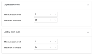
For MapProxy layers, display and loading zoom levels can be set in the layer settings.
The maximum loading zoom level defines until when a MapProxy layer is loaded. In this zoom level range data is actually reloaded. Normally, a layer should provide data up to at least loading zoom level 20 or 21.
The maximum display zoom level can be set differently from the loading zoom level. Example: A layer was created with loading zoom level 21. If the display zoom level for this layer is set to 24, users can still zoom up to level 24 in the viewer. Although no new data is loaded from zoom level 22 and the display becomes pixelated, a high display zoom level can be useful for measurements, for example.
The minimum loading zoom level defines from which zoom level data should be loaded. If the value is set to 0, data is always loaded. Setting higher values causes the layer to be displayed in the viewer only from a later zoom level. The behavior of the minimum display zoom level is identical. Thus, the minimum display and loading zoom level should be set to the same value.
Note: Defining high loading zoom levels is very memory intensive. So make sure you have enough disk space available and do not set loading zoom levels above 20 for layers that do not have high importance in the viewer.
