Classify & color point clouds
This tutorial describes how to classify and colorize points.
Classify & color point clouds via "Feature" Anchor
Point clouds are assigned to the type points in PlexMap and can be classified in the switchboard by using any polygons of the Feature.
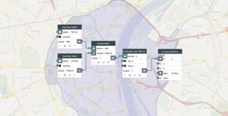
Our simple example shows the classification of building points using the Feature "ALKIS buildings". First, the Crop function is used to crop out all points of a point cloud from airborne laser scanning that lie within ALKIS buildings.
Afterwards, the remaining building points are colored according to their height using pointcloud.colorize_height and for visualization in a view in PlexMap 3D stored via Store in Layer.
This process can be run for additional Feature if needed. The result is a classified and colored point cloud. A demo application with further layers can be reached here.
Color point clouds via "Grid" Anchor
Another option for colorizing point clouds is the pointcloud.colorize_grid function. Here a point cloud of type points and a grid of type Grid can be specified as inputs. After executing the function, all points will be colored with the specified grid.
A popular application example for pointcloud.colorize_grid is the colorization of a point cloud with Orthophotos.
