Cut out True Orthophotos
True orthophotos, like many other geodata, are often delivered as mosaics. The required tile edges usually correspond to 500m or 1000m.
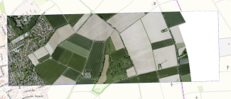
In the edge area of the surveyed area, which is defined for example by a county boundary or city district boundary, on the outermost tiles the areas outside the county boundaries are not stored with the real photographic image of the earth's surface in the raster image, but with a color value, often white or black.
In principle, the MapProxy layer can render these areas as transparent if the raster images are saved not only with the three color channels R, G, B but a fourth channel, the alpha channel. This channel reflects the transparency of the individual pixels. It has the same color depth as a color channel of the image and thus comprises 256 levels (0-255) for an 8-bit depth of an image. In these levels the transparency of the pixel is mapped from 0%-100%.
The PNG, TIFF, GeoTIFF and JPG2000 image formats support 8-bit alpha channels.
If you have received the True Orthophotos with only 3 color channels (R,G,B), we describe below how to remove the white areas.
"Masking" in the Switchboard Anchor
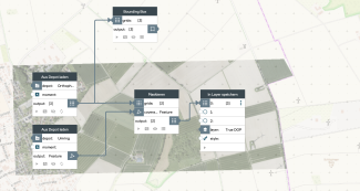
To process the raster images, they can be loaded from the depot into the switchboard with Load from Depot.
Another possibility would be to import the images from the system folder incoming of your instance, a more detailed description for this process can be found here.
In the next step you can use the function Mask to set all areas outside the geometry (for example city circle) to the value "nodata". This geometry must be of data type Feature.
Then save the thus masked grid images into a layer of type MapProxy. This layer recognizes the pixels with the value "nodata" and does not map them. So all layers below the raster images are visible in these areas.
MapProxy Layer settings Anchor
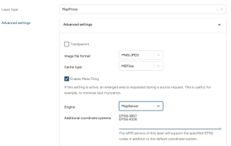
The recommended Layer settings for dynamic display of many orthophotos in a View are as follows:
Image file formatPNG/JPGCache typeMBTilesEngingeMapServer
For more information about "seeding a layer", i.e. making all tiles available immediately at all zoom levels, click here.


